July 17
Miles: 9.5
Today is the first real day of backpacking and I lurch-hike under the weight of my pack. “Goodbye lawyer couple!” I think as I leave their sleeping tent. “Good luck!” and I don’t even mean it sarcastically. I have to find a way to get to the Pohono Trail, which is my starting point. The Pohono Trail is 13.1 miles and at the far western end of Yosemite Valley. I decide to take the free shuttle as far as it goes, El Capitan, and road-walk to Tunnel View parking lot, which is the trailhead for the Pohono Trail. I pass the field in Yosemite Valley again and notice something different:
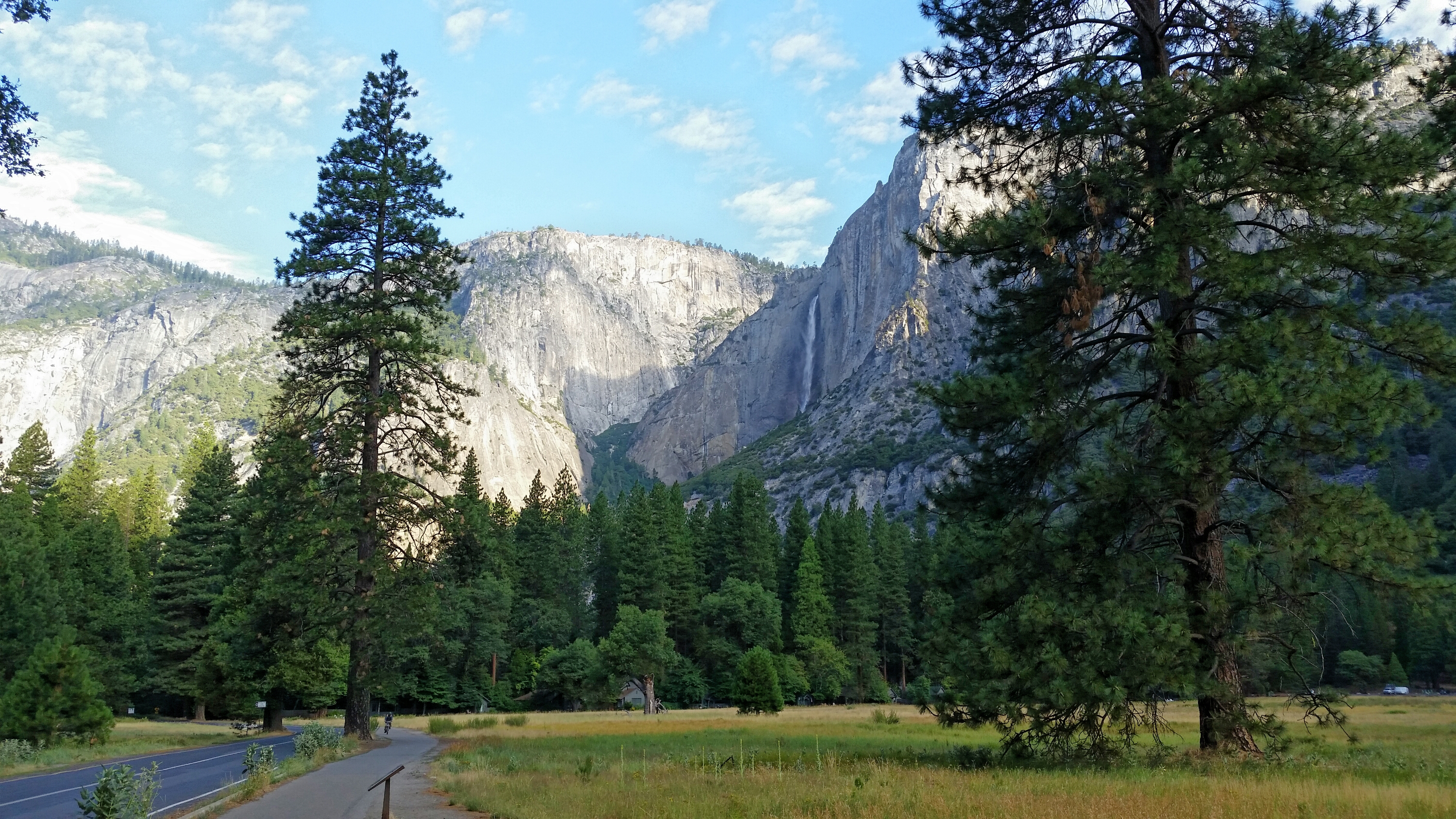
The waterfall! How had I missed it the day before?! I take a picture and walk on to the visitor center to catch my bus. While riding I talk to a young family from Sacramento. They tell me its not uncommon for the falls to be dry at this time of the summer and then come to life again a day after heavy storms in the mountains. I had noticed the thunder yesterday as I was making camp, so the rainfall must have worked its magic. Just past El Capitan (the sheer granite wall that’s three times the size of the Empire State Building, or so I’m told) the bus driver lets me off and points me in the direction of Tunnel View.
I begin to road walk. I see a trail in the woods and decide to take it. After a while I get the uneasy feeling like I’m going in the wrong direction, so I get back on the road and road walk again. Then a different trail, this time in the right direction (I think), and woods-walk. Back and forth. Where am I? This new trail begins to deteriorate quickly and soon I’m stepping under fallen trees, and stumbling on bits of asphalt trail that have chunked off and been kicked aside. “This trail is abandoned,” I think. “What trail is this?” I can hear the road far below me, but I can’t reach it and don’t want to backtrack. I should have stayed on the road. I knew the road would take me to Tunnel View. Roads! Humanity! Good, quality direction! But, I think, this trail will too. It must intersect with the Pohono Trail just as long as it doesn’t peter out into nothing, which would be very bad. I don’t want to have to bushwhack on my first day. As a show of good faith, I stumble on this view:
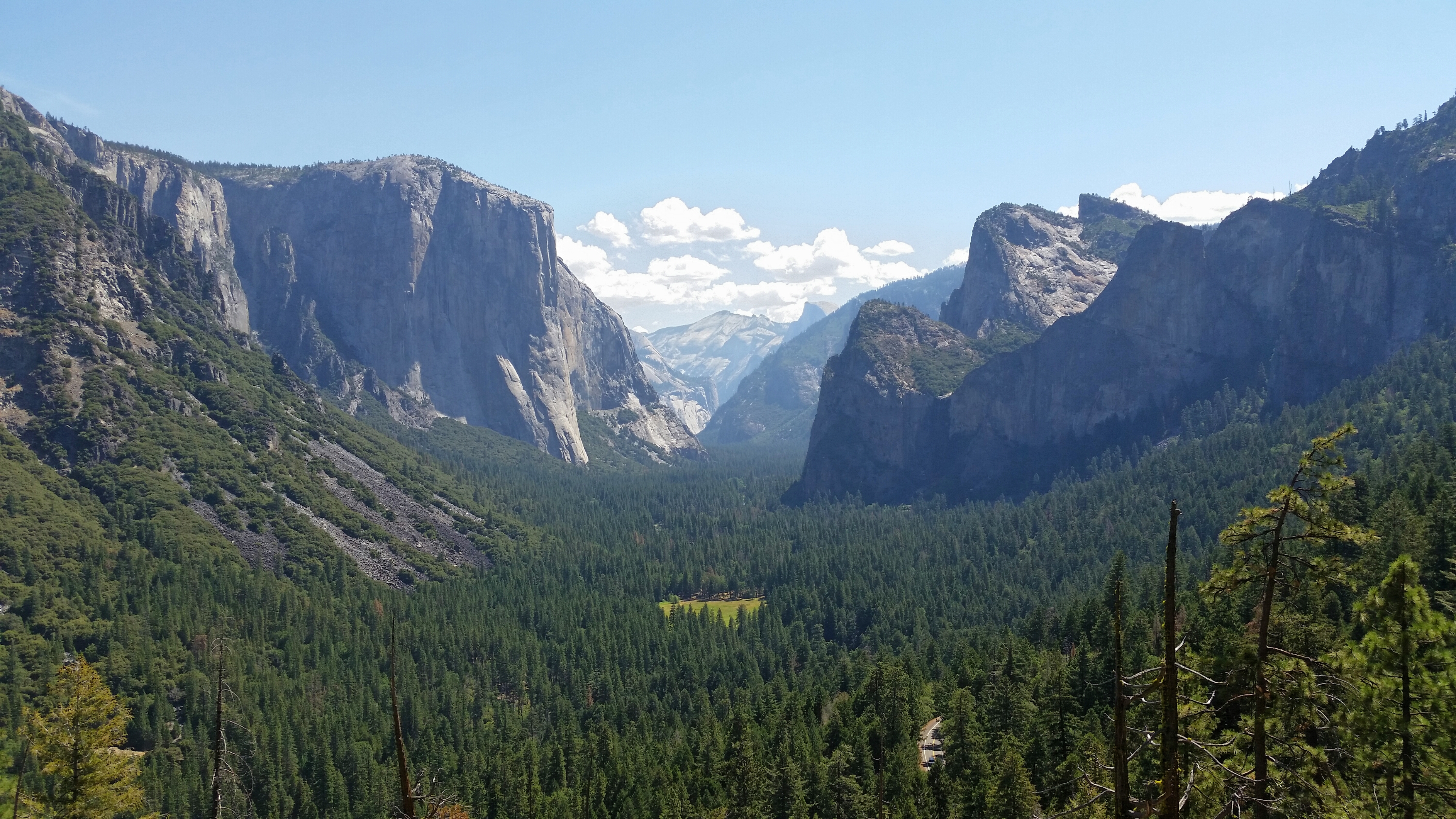
Well then. El Capitan stands tall on the left and The Three Brothers face it. Way off in the distance I can see Half-Dome, a wave caught crest-high and frozen into place. I’ve just begun my ascent from the valley floor but already the tops of the trees are well below me. I drink some water and remember what the ranger told me yesterday: water scarce on the Pohono Trail. I ration and limit myself to a few sips. I reach into my pocket to look at the map I picked up yesterday so I can ascertain just where I am. And…oh no…where’s the map? I have lost my map. I assume I left it behind on the bus. “It’s OK,” I think. “These trails are well maintained and marked frequently. I just have to, you know, find the actual trail.” I get up, walk on and just around the bend is the Pohono Trail. Already half a mile in progress. I take it.
At this point, I begin switch-backing up, up, up the steep side of the cliff. I am climbing out of Yosemite Valley and onto the south rim. I begin to stumble and look out across the valley at the opposite rim to gauge my progress and see how much farther up I have to go. Turns out, quite a bit. I happen across a family coming down and say something incoherent. “What did I just say?” I think.
“What?” The man says.
“Am I on the Pohono Trail?” I gasp. “I lost the map, and just want to make sure.”
“Oh.” He says. “Yeah, and you have some fine views up ahead.”
I thank him and walk on, relying heavily on my trekking poles. I put my head down and push harder. Sweat beads on my forehead and drips down off my nose. The dust of the trail absorbs it. I have about 6.5 miles to go to get to Bridalveil Creek, which is my campsite for the night and a sure source of water. Until then, I have no idea. I assume 2 liters of water to last me until then.
I sit down again and begin throwing handfuls of trailmix into my mouth. Cashews, almonds, M&Ms, all making my mouth dry and my throat thirsty. A few more drinks of water. I lick the salt from my upper lip. It tastes good. I stand and start hiking and after 5 steps my muscles scream out in protest. “No more!” they say. My heel doesn’t feel right, but I keep on and hit my stride shortly, only to lose it 15 minutes later. I sit and rest.
Three hours pass in this manner before the mountain throws me a surprise. Water! Trickling from some source further up! I drink down what I have (about half a liter) and refill everything. I sit and slowly drink a liter of fresh water. Eventually I get up and slowly move on, recharged.
After a number of false ridges I reach Stanford Point, which signals the half-way point (roughly) to my campsite for the night. I sit on the rock and take in the view:

I’ve made it above the Three Brothers, but El Cap tells me I still have a way to go. I look out into the valley below me: the trees growing up the side of the mountain, the cliffs colored every shade of grey imaginable. The main road creeps along like a thread unwoven. The Merced River, peaceful and still from this height. Off in the distance, I can see the landmarks I will arrive at in the coming days. They look so far away and the idea of walking to them feels like an antique thought in my head. My feet: outdated modes of transportation.
I sit on the sun-baked cliff and eat from a little pot of refried beans, spread onto a tortilla with fritos chips. It is delicious.
On the trail again, I pass Crocker Point and Dewey Point, each a little higher than the one before it. Dewey Point stands at 7400 feet. Tunnel View was at 4400. 3000 feet in an afternoon. I go on cruise control and pass deep forested hollows with large old trees. Moss covers their trunks, and now instead of grey everything takes on a green hue.
I kick up dirt as I walk the final stretch to Bridalveil Creek and nearly faint when I see the bridge and hear the running water. It took me almost 8 hours to go 9.5 miles. I couldn’t go much farther. I quickly make camp and walk down to the shallow pool beneath the bridge and jump in. I refill my water and wash my socks. The water turns brown and murky before the current disperses the dirt and pushes everything down stream.
Night comes on slowly as the sun casts a fine light off the to the west. The cirrus clouds far overhead turn a deep orange. The stream, 100 feet below me, flows calmly. The forest goes to sleep, and I with it.

One thought on “Up!”